The Broke Backpacker is supported by you. Clicking through our links may earn us a small affiliate commission, and that's what allows us to keep producing free content 🙂 Learn more.
Madeira Island – a small autonomous Portuguese volcanic isle found off the North West Coast of Africa is an absolute paradise for hikers of all types. With a plethora of hiking trails, with a variation of elevation gain, and an almost guaranteed glass of fortified wine at the end… Sounds like heaven to me.
When most people think of Madeira, they think wine and sunshine. A fair conjecture, but there is more to Madeira Island than these simple pleasures. Madeira wine is most definitely fine though and I highly recommend making this a central focus of your trip (alongside the hiking, obvs).
There are not many places on earth with the unique combinations of landscape features found here. From LUSH rainforest and fern gardens, old forests, towering waterfalls, massive waves, epic cliffside coastal viewpoints, to mist-covered mountain peaks – you get the idea.
I cannot recommend enough that you visit Madeira, the whole island is home to natural landscapes quite unlike any other. From the highest peak to the capital city, you’ll find interesting people (and steep drops!). Madeira hikes will take you on windy roads, wide paths, get you up for early morning sunrises and create memories that will stay with you forever.
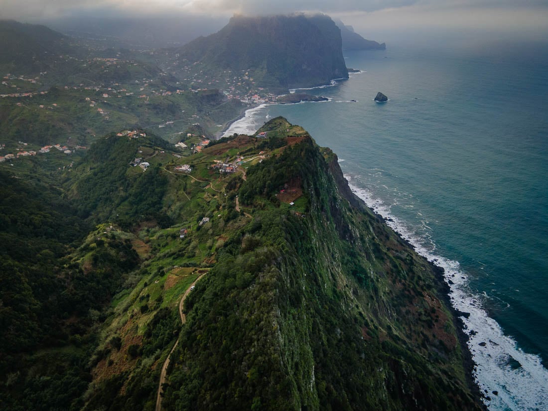
Photo: Chris Lininger
The Broke Backpacker is supported by you. Clicking through our links may earn us a small affiliate commission, and that's what allows us to keep producing free content 🙂 Learn more.
Another notable fact about Madeira is its size. There are no great distances to deal with when it comes to moving from your base in town to any given trailhead. In one week, you can easily hit different hiking trails every day in different parts of the island if you have a rental car.
There are so many natural landscapes to choose from to immerse yourself in while you’re backpacking in Portugal. Parking up in Madeira for a while means you’ll have plenty of hiking trails to consider, minimising your decision fatigue. Here are some of my favourite classic and off-beat hikes in Madeira…
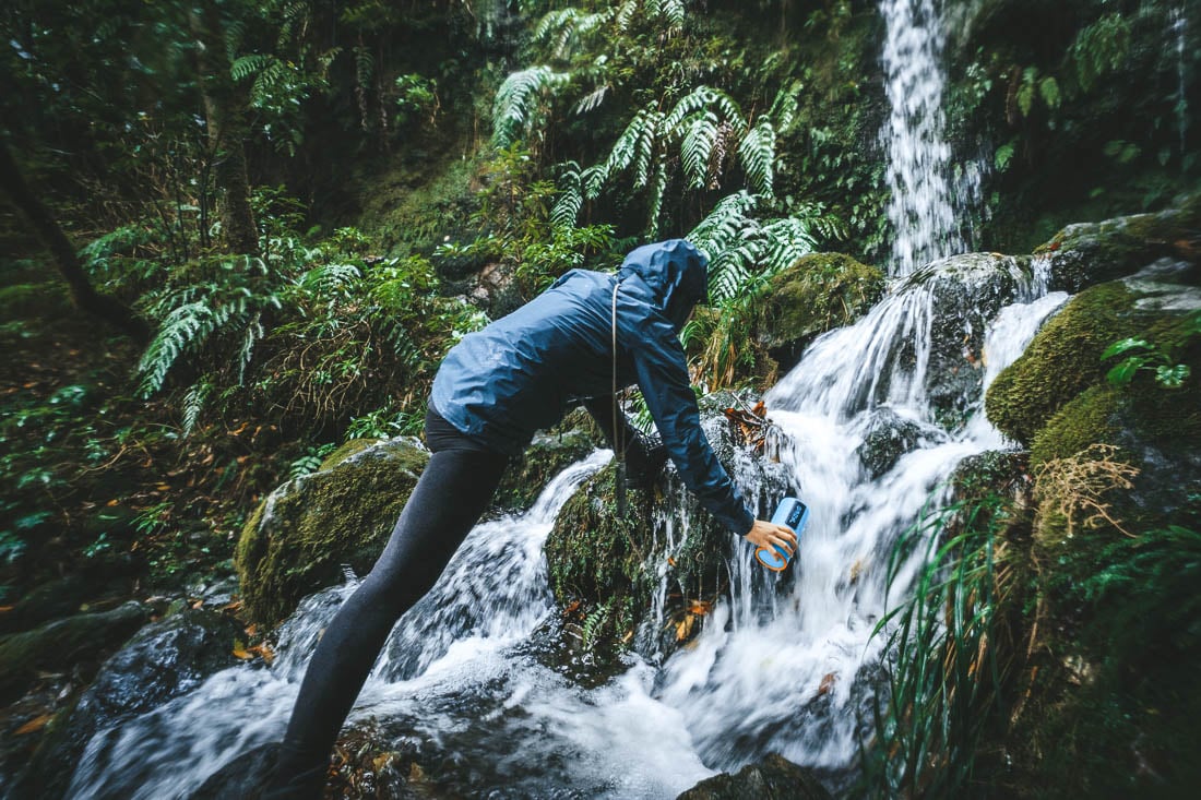
1. PR9 Levada Do Caldeirão Verde (Levada of the Green Cauldron)
My first hike on Madeira, the Levada Walk, is a classic out-and-back route that is a must when visiting this magical island.
Pack yourself a sandwich to stick to that low budget travel life and get ready for some unreal scenes. Along the track, you will find lush greenery, epic mountain views, babbling streams, plenty of waterfalls, and several tunnels that cut right through the hills. More on the tunnels in a minute.
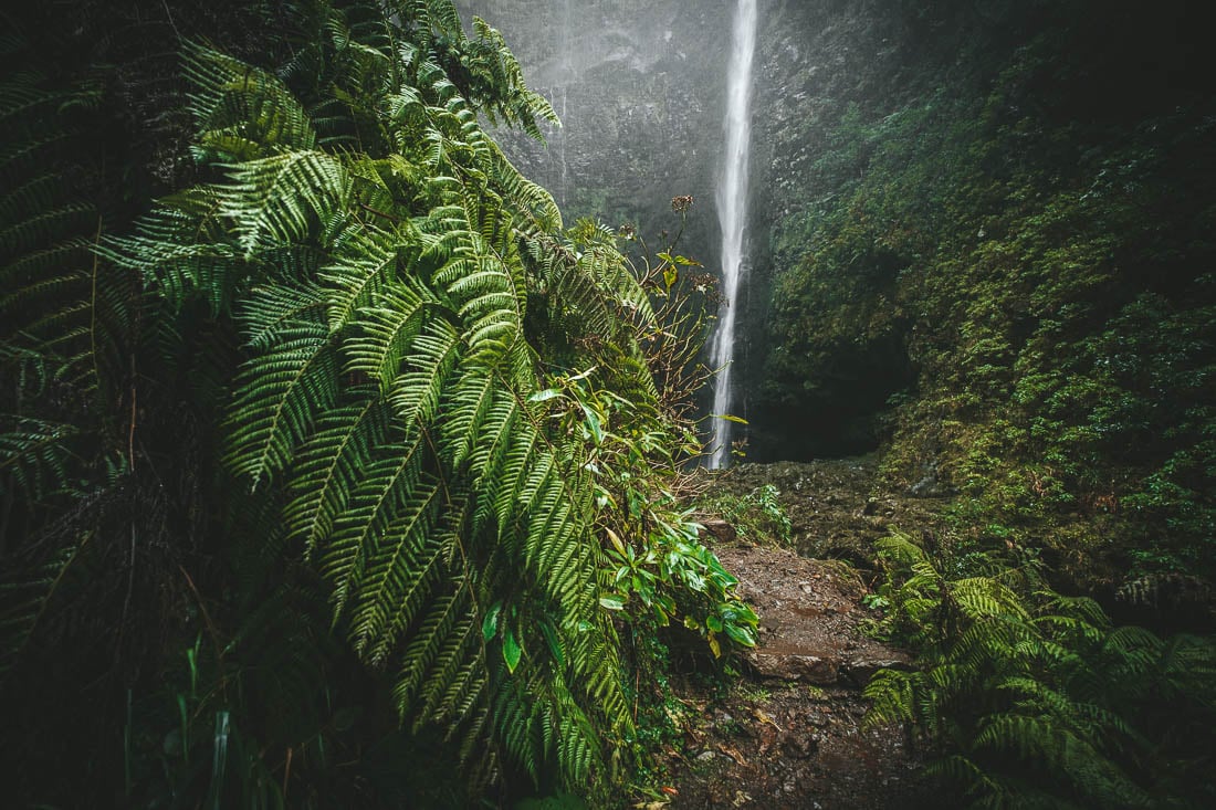
So, what is a Levada? Levadas are old irrigation canal systems found all over Madeira, and nowadays, many of the best hikes in Madeira follow these Levada walks. The Caldeirão Verde hike is a great intro to the hiking trails for your first days on the island because there aren’t any steep drops. Plus, the vibe of the forest and scenery are truly something special, your travel fitness will not slip on this trip.
- Distance: 12 Kilometers
- Duration: 4-5 hours with food breaks and photo ops.
- Difficulty: Easy/Moderate
- Distance from Funchal to Trail Head: 45 mins
Getting There
As is the case with most treks in Madeira, you will need a car to reach the Levada Do Caldeirão Verde trailhead from Funchal. Total drive time from Funchal was around 45 minutes.
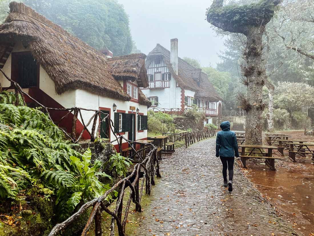
You can park your car at the main trailhead, just below the beautiful old cottage buildings, which are a cafe and reception. The buildings are very distinct, almost Swiss-style, and the cafe is a great place to sip a hot espresso and chow down on a cake. The cottages also offer overnight accommodation, a nice change of pace from hostel life.
The car park is paid parking, and you can get up-to-date pricing from reception. Once at the buildings, lace up your hiking boots and walk up the broad leafy path to the right of the buildings, to the trail.
Trail Conditions and Route
As mentioned, this hike does not cross any overly steep or strenuous sections. Regardless, if you’re travelling solo, stop into the cafe or reception and let them know you’re going in so someone knows where you are. You gotta be witty about your own safety!
When I did this hike, it was rainy, and small waterfalls poured onto the trail from above in places, which was scenic AF. The trail itself was muddy, so I would recommend hiking boots and starting by mid-morning. This way, you’ll have all day to scramble in the mud and enjoy the scenes.
Given that Madeira is an island of microclimates, this area, in particular, is so green and lush because it receives a fair bit of rainfall. Definitely pack a rain jacket, gaiters, and a backpack with a rain cover.
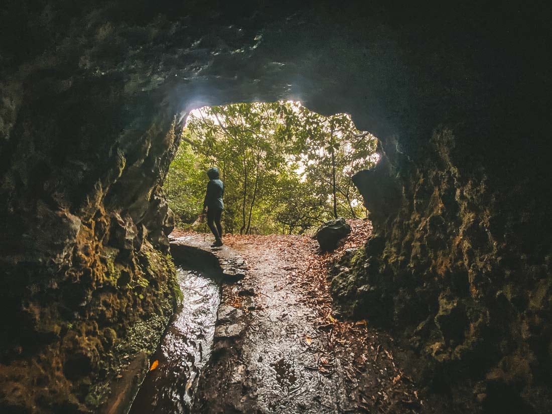
As mentioned, a unique aspect of this trek is all of the tunnels you pass through en route to the main waterfalls! The natural landscapes that create these are phenomenal – some of them are as long as a few hundred meters. Mind your head when passing through them, as the “ceiling” in some places is quite low.
The halfway point of the trek (6 km in) is when you reach the main waterfall (the Green Cauldron). This is an epic spot to chill out and eat some lunch. Note that due to a landslide in recent years, there is signage stating that the path to the main waterfall is closed.
Nobody was around, and we did not feel like the conditions were overly dangerous at that time (even though it was raining a bit). It is your call to judge your own safety, whether or not you continue past the sign to the waterfall, which we did. Travelling as a couple definitely has its perks – partners in crime being one of them! 😉
If you’re feeling motivated, the trail starts again, and you can carry on 2.4 km to a second waterfall, called Caldeirão do Inferno. This will likely add two hours onto your journey, but it is well worth it if you have the time, from the photos I have seen. Because we started the hike late (around one pm), we opted not to continue on to the Caldeirão Do Inferno.
Best Hiking Tour in Madeira
This EPIC Hiking Tour in Madeira will have you trekking from Santana to Funchal over 6 Days. You’ll be trekking through many of the trails included in this post!
- Number of days: 6 days
- Group Size: Max 15 (average 12)
- Fitness Required: High, this trip involves lots of hiking!
- Accommodation type: Comfortable family run hotels
2. Vereda Do Ponta De São Lourenço Hike
Another classic route on Madeira, the Vereda da Ponta de São Lourenço Hike brings you to the most eastern point on Madeira. Where land’s end meets the sea and you can see the Canary Islands (not actually, but if you could, then it’d be here). This is an easy (relatively) short walk, an epic option for an after-work mission if you’re here on Madeira Island as a digital nomad.
This spot is famous for epic coastal views, the red-clay jagged cliffs and hills, and unique rock formations. These natural landscapes that make up Madeira hikes have been sculpted over millions of years by the pounding of the Atlantic Ocean and wind.
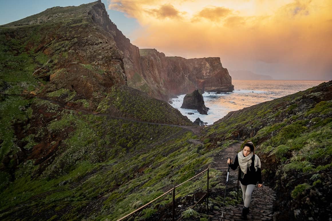
Photo: Chris Lininger
If you are a drone pilot, Ponta de São Lourenço Hike may fast become one of your favourite hikes of all time. From the air, some of the last landmasses (cut off from the hiking trails and mainland by seawater) resemble a tail. Which is why somebody aptly named it “the dragon’s tail”.
- Distance: 7 Kilometers
- Duration: 2-3 hours with food breaks and photo ops.
- Difficulty: Easy/Moderate
- Distance from Funchal to Trail Head/Parking: 30 mins
Getting There
The Vereda da Ponta de São Lourenço Hike is a very popular day hike for both locals and foreigners. So the best time to come here from a foot traffic perspective is early morning for sunrise.
While you’re staying in Madeira, you’ll probably be in the capital city. The drive from the Funchal City Centre takes 30 minutes or less if there is no traffic. There is rarely traffic on Madeira, from what I have seen, and the trail starts from the car park.
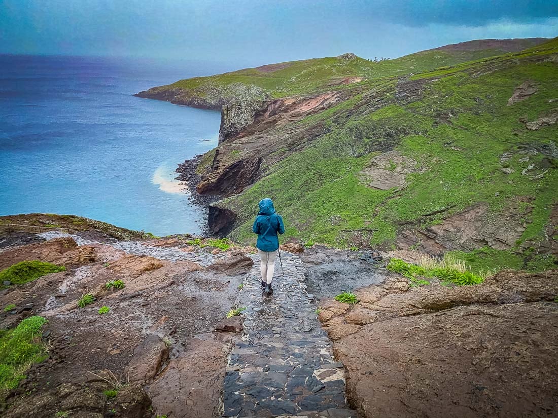
Photo: Chris Lininger
Parking at the trailhead is free. Just as a common-sense tip, I would not leave anything of value within sight within your vehicle – better safe than sorry, right?
Trail Conditions and Route
From a safety perspective, the track felt very protected and was easier than some other hiking trails. It has the track edges roped off in exposed places and has a wide path, which feels quite safe. Wide enough to walk side by side if you’re travelling with a buddy.
There are moderate elevation gains and losses throughout the seven kilometres of hiking trails (out-and-back), but nothing that will leave you huffing and puffing. There are a few hundred meters of elevation gain at the most.
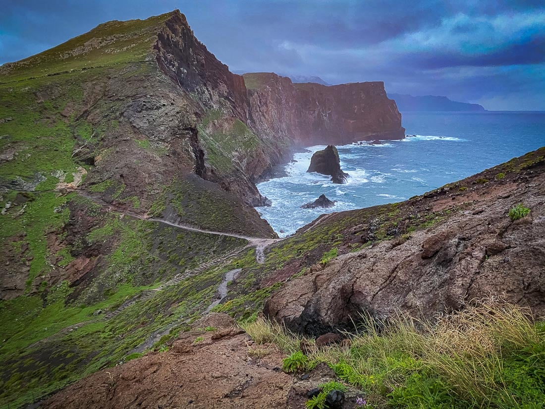
Photo: Chris Lininger
Generally, the trail was quite muddy and slippery in places, especially if you came on a day when it had been raining.
In some places, when it was dark, the trail was a bit hard to follow initially, so be sure to have a good headlamp. Also, Maps.me has the whole hike charted and is very accurate.
On the morning we went for sunrise – we were the only ones there – and you are about to find out why.
When you Find Bad Weather…
We learned the hard way that the weather on Madeira’s high cliffs can be fierce and does not always cooperate. If you have spent some time staying in Portugal, the occasional harsh weather here may come as a shock to you.
First of all, we arrived about an hour early in the dark: around 6:30 am, and sunrise was not until 7:42 am (in November). It was legit dark because of all of the clouds until 7:40 am. This would normally be fine, but since it was raining the whole time in the dark, it was less than ideal.
After a few minutes of hiking, the rain was coming down so hard that it felt like we were sitting under a showerhead. The wind was also deafening, especially in the higher, exposed jagged peaks, maybe not the best time to visit Portugal, but yolo! All we could do was laugh, as it was pretty comical and absurd to have so much weather happening all around us.
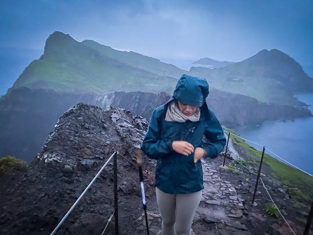
Photo: Chris Lininger
We did not get much of a sunrise, unfortunately, due to rain and cloud cover. This explains why the photos included here are not so good (photos are from my iPhone, as it was too rainy to pull out my mirrorless).
Lesson? Be sure to check the weather forecast before setting out – which we did- but also be aware that the weather can change rapidly. This part of the island is known for its volatile weather, so it just comes down to what happens on any given day. Hopefully, you will be luckier than we were because in fine weather, the views are insane.
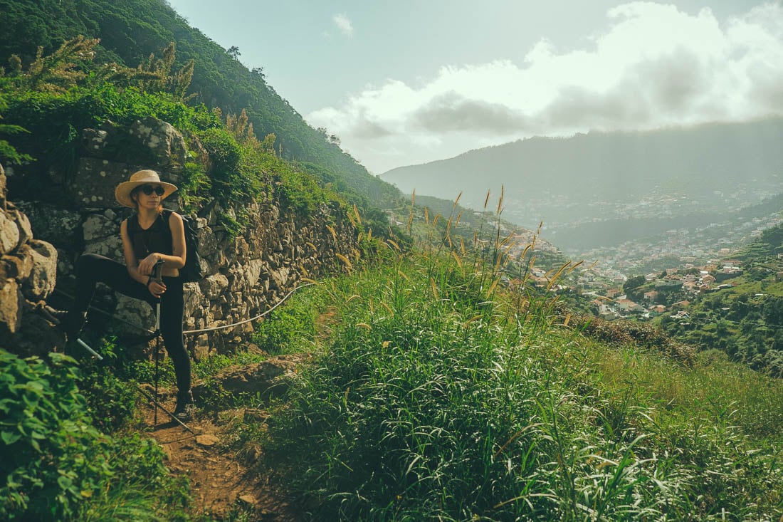
3. Vereda Do Larano – Levada Do Caniçal Coastal Hike
For accessible, sweeping-vista coastal views, Madeira’s trails don’t get much better than the Vereda do Larano – Levada do Caniçal hike. This trek takes you from a meandering forest track that runs through small garden plots and rural houses to an absolutely stunning vantage point. Perched on high cliffs, looking down on the vast sea surrounding this small island below.
If you are looking for that quintessential Madeira coastal hike where the views are grand, the difficulty is moderate, and the trail is safe… Look no further. With scenes like these and a notoriously low cost of living, moving to Madeira is looking attractive, eh?
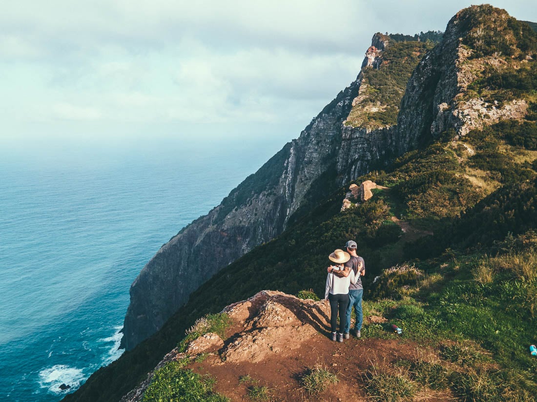
Photo: Chris Lininger
Another plus to this hike is that, though fairly long, the degree of strenuous difficulty is minimal. This makes it an ideal hike for casual day hikers, photographers, and the like.
- Distance: 13 Kilometers
- Duration: 5-6 hours with food breaks and photo ops.
- Difficulty: Moderate
- Distance from Funchal to Trail Head (Manchico): 30 mins
Getting There
To start this hike, you have a few options. Most people start the hike at Levada do Caniçal / Machico side and finish in Porto da Cruz. You could do it the other way around, I suppose… Or if you did not want to do the whole thing, one can start in Porto da Cruz and return there after a few hours.
Doing the end-to-end hike is the way to go, though (Machico -> Porto da Cruz ). Ending in Porto da Cruz is much better as well because there are many food/drink options, yes, Madeira wine, and lots of it. Whereas at the start of the Levada do Caniçal, there is nothing around, you gotta get that post-hike fortified wine, baby!
The Madeira archipelago is home to one of the most famous fortified wines in the world. All fortified wines produced in Madeira fall under the Madeira DOC. Make sure you take a winery tour of these fabulous Portuguese wineries.
Photo: Chris Lininger
On this day, we did not have a car, so we took an Uber from near the airport (€9) to the start point. We then took an Uber back to Funchal afterwards from Porto da Cruz (€25 ouch). If you don’t do the hike on the weekend as we did, there are more public transport options on the regional government website.
If you do have a car, there is limited parking around the Levada do Caniçal start point area, but you’ll find something. The easiest way to get back to your car from Porto da Cruz is to take an Uber (which costs around €10).
Trail Conditions and Route
I’ll be honest, though pretty, the first few hours of this hike are not mind-blowing. The track follows the levada canal through overgrown grass, small gardens, and run-down, charming old houses. Stay with me, though – the best is yet to come on this Levada walk.
There are a few points where the trail forks, so be sure to pay attention when you come to a road crossing. The trail at that point is found directly across the road, down some stairs. Use Maps.me to stay on track.
A majority of the hike is exposed to the sun, so it is a good idea to wear a hat and use sun cream. Hiking trails that score the mid-morning sun are my favourites, but take into account your own safety.
After roughly 5 km, you will get to another fork. Be sure to take the uphill path at the sign that says “Vereda Da Boca Do Risco”. This is a crucial juncture so look out for the sign!
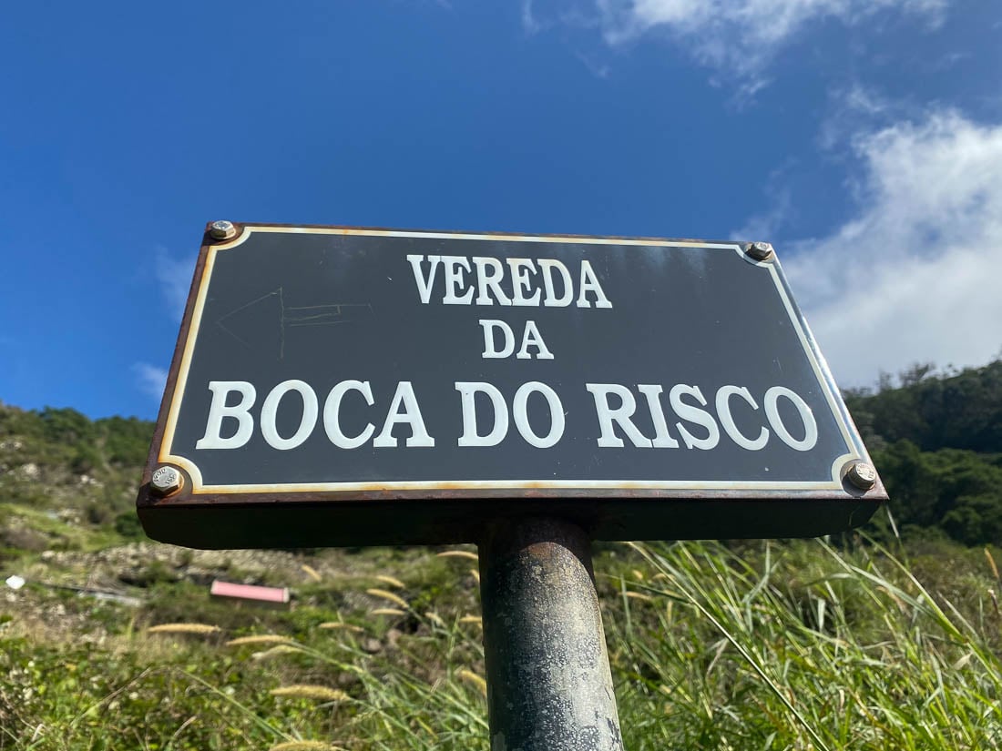
Photo: Chris Lininger
After a bit more time, this track ends/forks (seemingly out of nowhere) and merges with the Lavano Walk. This happens at the top of a gorgeous viewpoint and small meadow – an ideal spot for lunch and drone flight. Boom – oh, hello beautiful sea, and thanks, elevation gain.
From here, you take the well-maintained trail along the cliffs and through the coastal forest for the remaining kilometres. You’ll wander along the hiking trails, passing massive drop-offs and epic waterfalls along the way. At no point do you descend to sea level.
The last few km of the trek, unfortunately, are on the road. Taking you into Porto da Cruz, not the capital city, but definitely home to some good Madeira wine. Once you hit the road, don’t worry, you are still going the right way, and there will be a glass of fortified wine to quench your thirst.
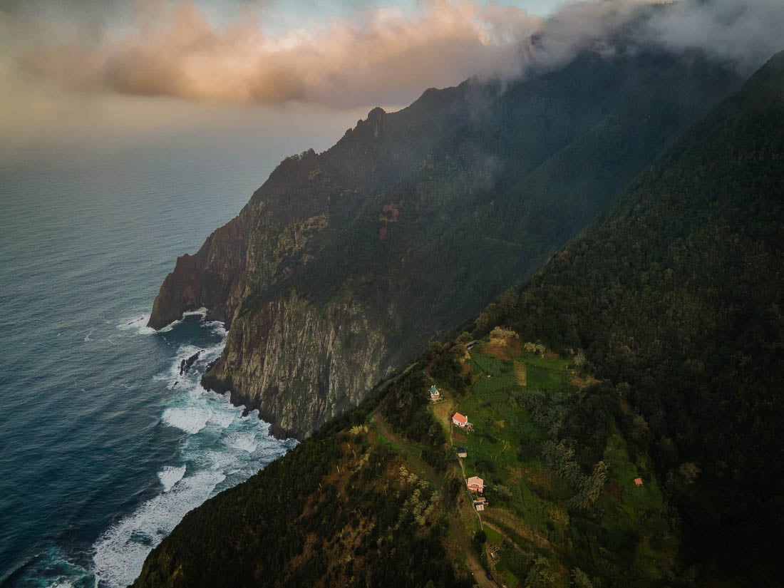
Photo: Chris Lininger
Once in Porto da Cruz, it is time to chill out, get something to eat, and enjoy that Madeira wine. When you are ready, call an Uber back to your car in Machico or take the bus back to Funchal (the capital city). Note that the last bus back to Funchal on weekdays is 6 pm.
4. Paul do Mar Faja Da Ovelha Loop Hike
There is a saying here on Madeira, “there is always somewhere with good weather to be found”. When rain and cloud are bearing down on the interior around Sao Vicente and the unstable north coast… The quaint village of Paul do Mar in the west of Madeira offers a pretty consistent dose of sunshine and stable weather.
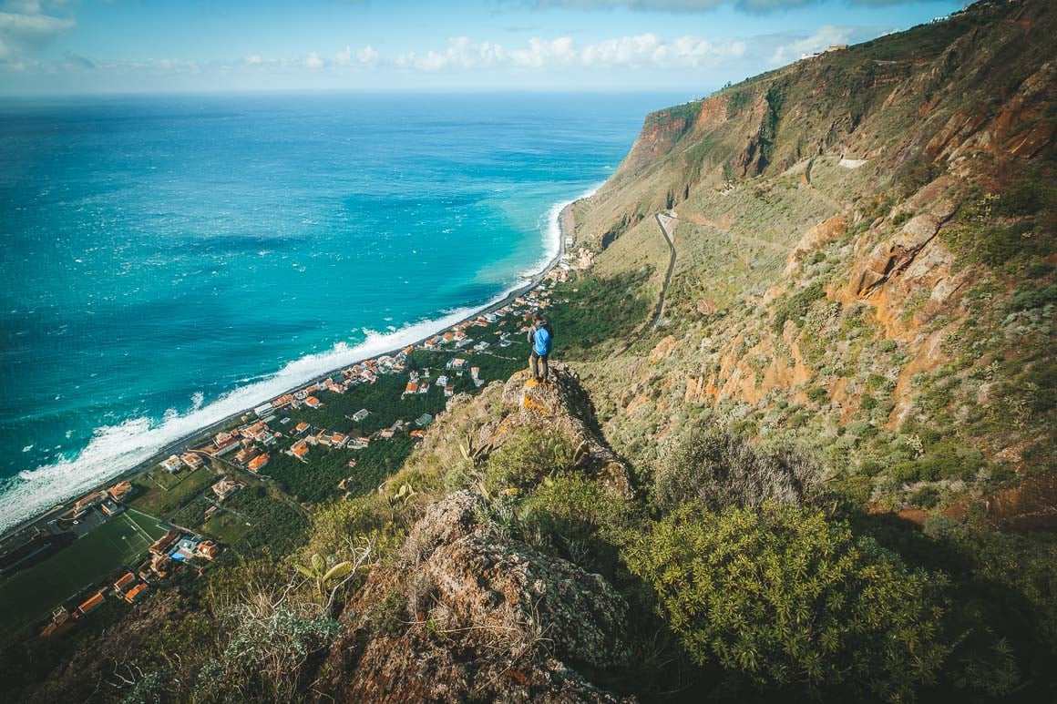
Photo: Chris Lininger
This fun loop hike takes you into the hills above Paul do Mar, where the hiking trails pass cactus patches, small farms, and epic viewpoints. You can start this hike on either end of town, but I recommend starting at the far western side of town. This way, you’ll end with a slight elevation gain and the best views of this epic island in Europe.
On a clear day, you can see the beautiful turquoise water tones of the sea below. From Paul do Mar right to the neighbouring surf destination town Jardim do Mar.
- Distance: 11 Kilometers
- Duration: 4-5 hours with food breaks and photo ops.
- Difficulty: Easy/Moderate
- Distance from Funchal to Trail Head: 1 hour
Getting There
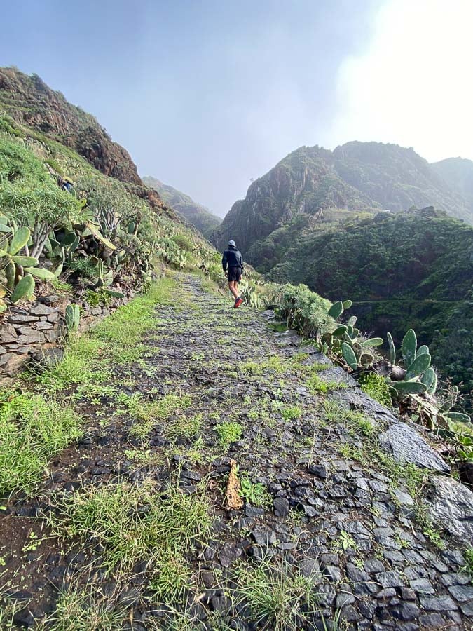
Photo: Chris Lininger
From Funchal, it takes roughly 1 hour to 1 hour 10 minutes to reach the start point of the Faja Da Ovelha trail.
You can park on the main “promenade” street by the sea wall and walk to the far end of town to start the hike.
If you are looking at the sea, walk to the right until you find the path that immediately starts to take you up the ridge and walk to the very top.
If you have any trouble finding the start, simply ask a local person at one of the bars nearby. If you are using Google Maps, you can set your pin to here.
Trail Conditions and Route
The trail is well-trod and well-maintained with no dangerous exposure. There were some steep, muddy and slippery sections on the descent, though, so bring your trekking poles if you have some.
Like many places on Madeira hikes, there are many side trails to be found here. When I did the trek with a group, we looped around the ridge to join the Vereda da Atalaia trail for our descent – awesome views. This day, despite Paul do Mar being one of the sunniest parts of Madeira, saw us changing layers at least five times. As always, bring the right gear so you can be comfortable when the conditions change.
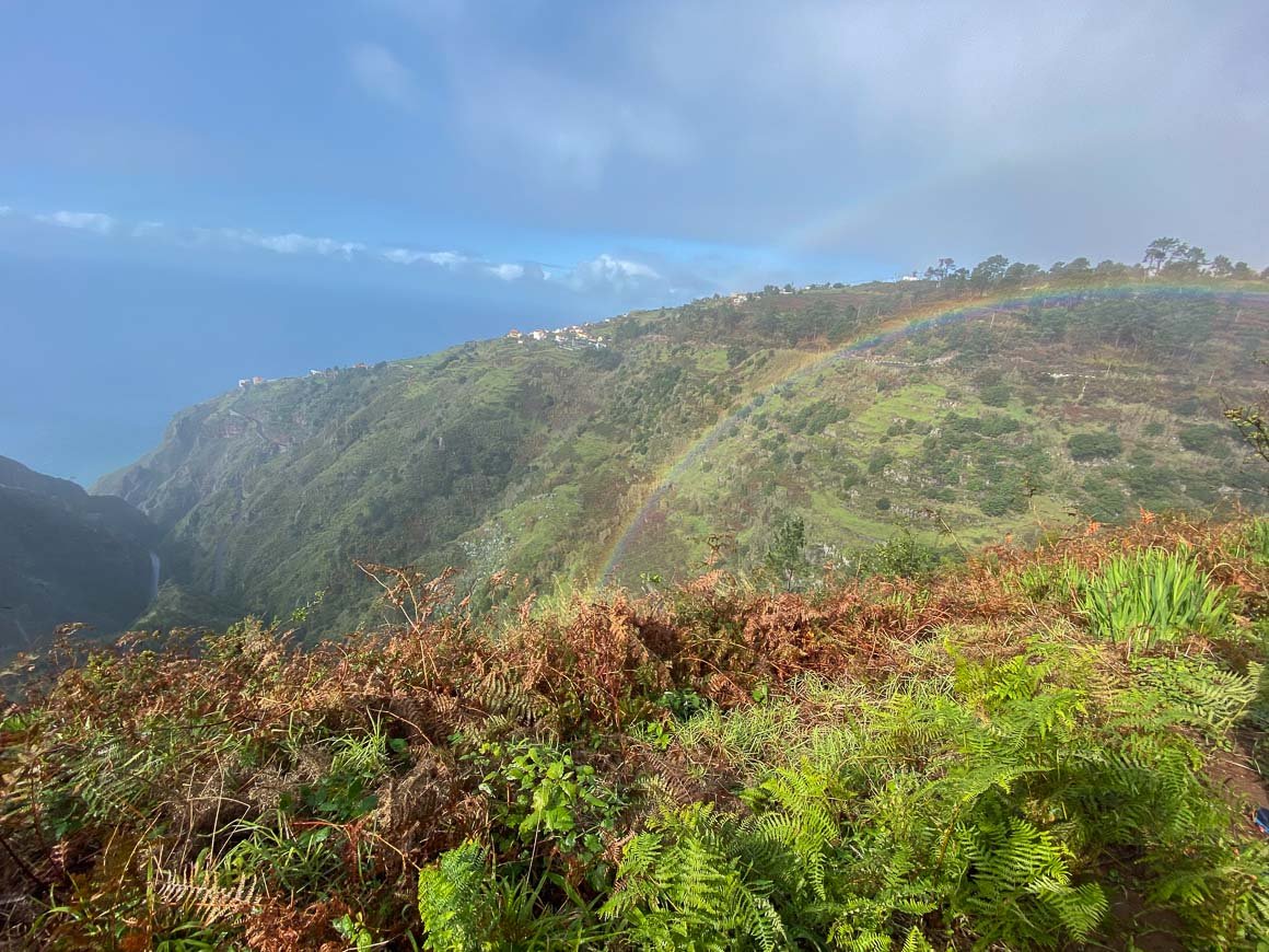
Photo: Chris Lininger
If you time this trek right, there are some great viewpoints to watch the sunset here. Make sure you bring a head torch if you plan on finishing the trek in the dark.
Map.me is a great resource to use to stay on track for the descent. I would not fear getting lost on this one, as there are really no moments where you feel totally away from civilisation. Most of the time, you can still see Paul do Mar below.
When you finish the hike, there are a few good places to get some food, but I recommend heading over to the historic centre. The old port area of Paul do Mar has some legit fish and chips and a glass of red wine at Bar Ideal. Their poncha and lapas are also on point.
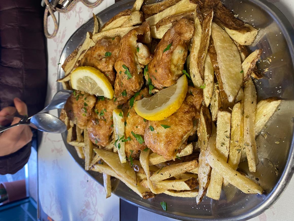
Photo: Chris Lininger
5. The Pico to Pico Hike: Pico do Arieiro to Pico Ruivo
The Pico do Arieiro to Pico Ruivo trail is probably the most famous and popular mountain hike in Madeira. And for good reason… This trail is very accessible from Funchal. You can essentially drive to the summit of Pico do Arieiro just for the sunrise (which MANY people do every day) if you don’t feel like hiking.
It is usually a good idea to check the webcam on Arieiro before you drive up there… If you are not going for a sunrise, that is, otherwise the cam will be black.
In terms of accessible dramatic landscapes, the views around Arieiro at sunrise are hard to beat. On the morning I went for sunrise, we had a bit of cloud inversion happening in the valley below. If you get lucky, the clouds will be much more epic than the drone photo below shows.
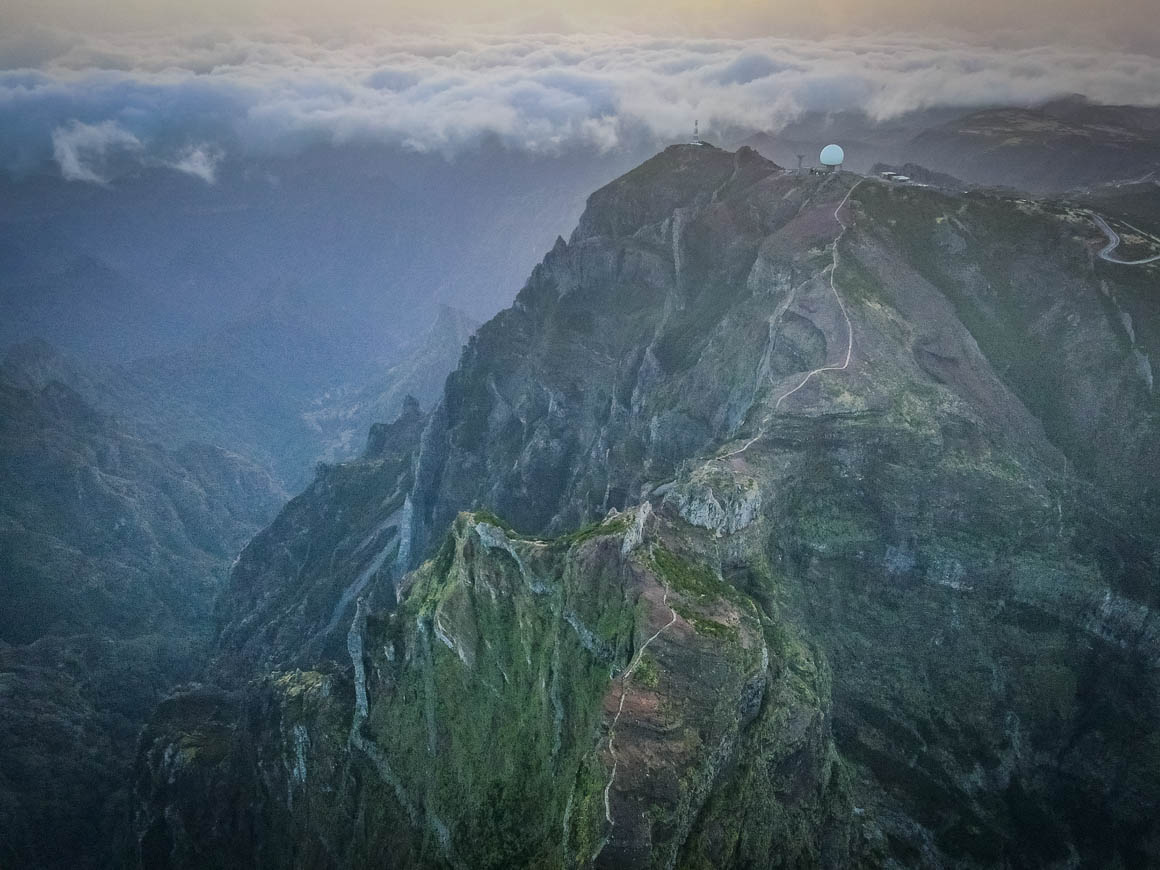
Photo: Chris Lininger
There was never a boring view on the hiking trails to Ruivo and back. So if you only have time to fit in one serious mountain hike in your Madeira itinerary, do this one!
After doing many more hikes than the list of the best hikes in Madeira would suggest, I can say that the Pico do Arieiro to Pico Ruivo trail was the busiest trail I have experienced in Madeira… But even so, go for it – this hike is a must.
- Distance: 11 Kilometers
- Duration: 5-6 hours with food breaks and photo ops.
- Difficulty: Moderate/Difficult
- Distance from Funchal to Trail Head: 30-40 mins
Getting There
As mentioned, the parking area near the Pico do Arieiro summit is a short drive from Funchal (about 30 minutes early in the morning).
Plug in this Google pin and park here to start the trek or to watch the sunrise.
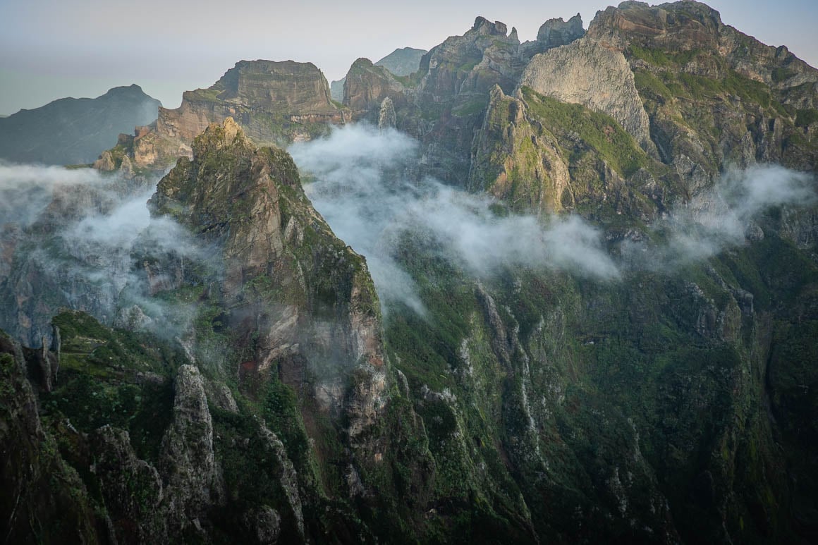
Photo: Chris Lininger
Most rental cars I have used in Madeira have small engines. So it’s worth noting that the road to get here from Funchal is steep, and for a small car, it is slow going at times. But never fear… You will make it eventually.
If you are coming for sunrise, try to arrive 30-45 minutes before the actual sunrise time.
Tip for sunrise: Instead of going to the famous Arieiro viewpoint, I recommend heading right for the trail to Pico Ruivo. Walk for 10 minutes until you reach the Miradouro do Ninho da Manta viewpoint. I watched the sunrise alone from here (there were probably 50 people at the other point), and I preferred the view to the classic spot.
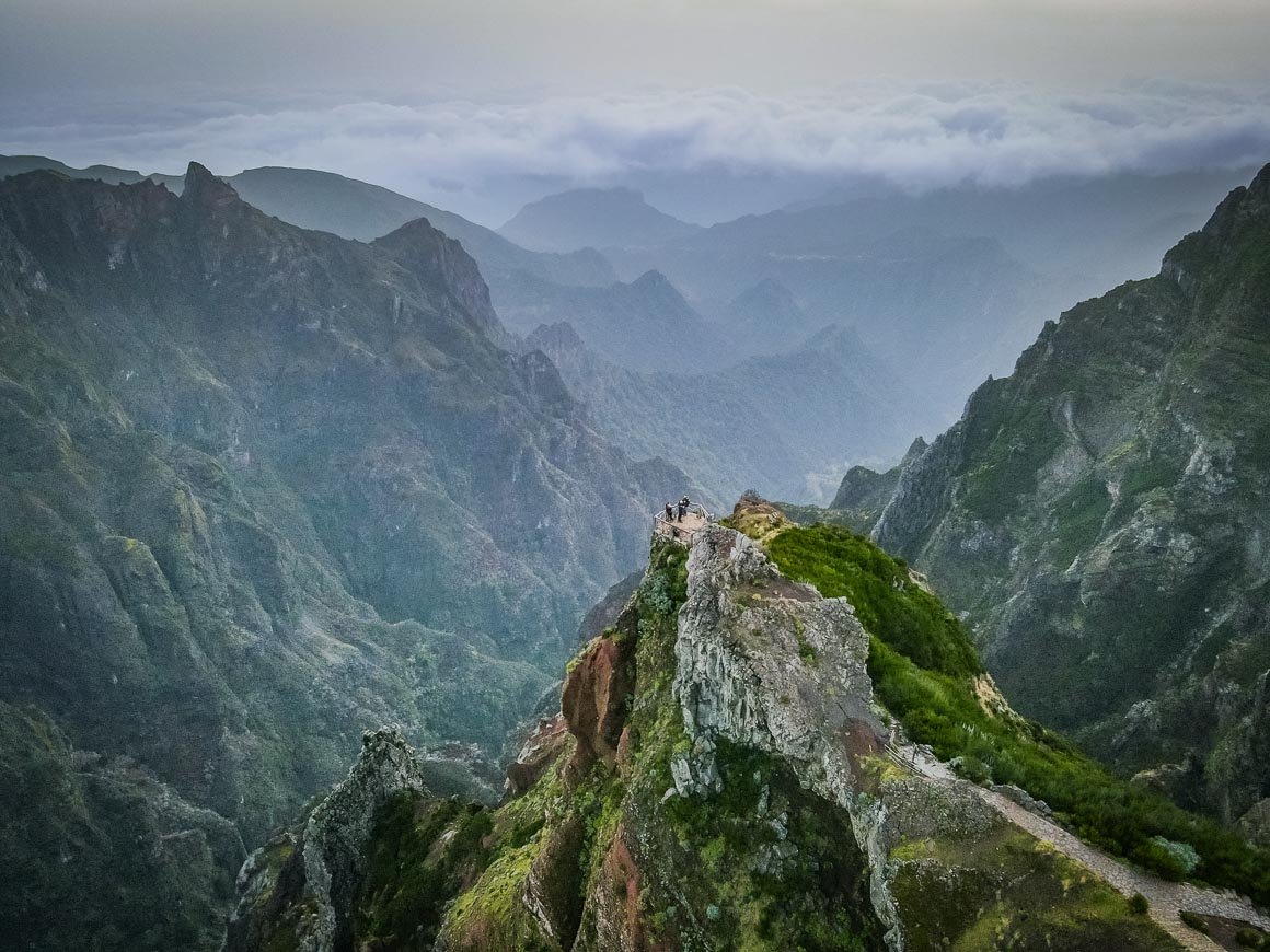
Photo: Chris Lininger
The most common of the hiking trails (there are a few options) is the out-and-back from Pico Arieiro – Pico Ruivo – Pico Arieiro. This is roughly 11 km and features 800-850 m of elevation gain throughout the hike.
Trail Conditions and Route
Just so that we are clear – again – the route I am describing here is not a loop or a one-way hike. You start the trail from Pico Arieiro, and you finish the trail at Pico Arieiro after returning from summiting Pico Ruivo.
However, there is the option to do this trek as a one-way trip to Encumeada or finishing in Achada do Teixeira below the Ruivo summit. Both of these routes involve the logistical challenge of getting back to your vehicle at Arieiro.
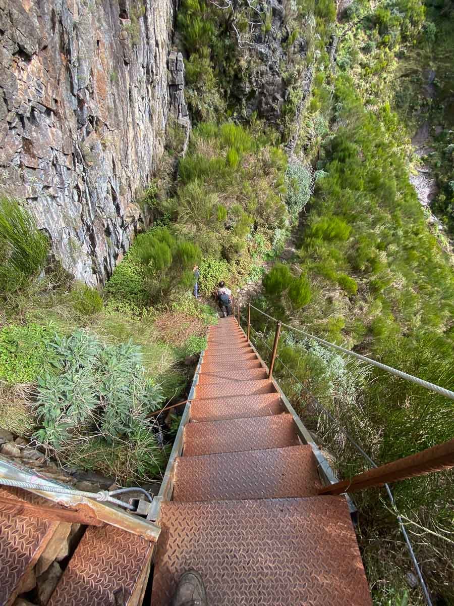
Photo: Chris Lininger
Generally speaking, the Arieiro-Ruivo trail is well maintained and often features beautifully laid stone paths and mason work. There are a few sections on the approach to Ruivo that involve steep stair climbing.
When I heard about the stairs, I heard them referred to as “the stairs of death” because they are never-ending and steep. But in truth, though tiring, the average hiker will not find them too difficult (though your legs will burn).
Note that there are a few dark tunnels to pass through along the trail, so having a headlamp is a good idea.
The summit of Pico Ruivo was chilly and a bit windy, so be sure to pack a good jacket and even some gloves.
There is a nice cafe just below the Pico Ruivo summit where you can eat your lunch in the sun (if it is out) and buy a coffee or a beer.
6. Levada do Plaino Velho Hike
I’ll start by saying that after two months on Madeira, the Levada do Plaino Velho hike is one of the top three hikes I have done. If you have the time, you are an experienced hiker, and you have the motivation for this hike – I hope you go for it. One of the most beautiful places in Portugal.
This hike is unique for several reasons. It starts you off at an incredible viewpoint (Pico Ruivo do Paul) and winds down into the valley below through a truly stunning forest. It feels like the lost world that parts of Madeira truly are.
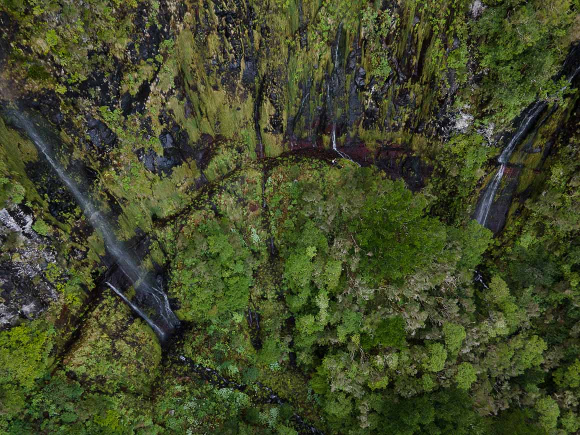
Photo: Chris Lininger
I have only heard of a few of my friends doing this hike recently – before that, who knows who has been here in the last year or more.
If you want a good combination of wild/off the beaten path/mountain views looking down onto the sea… AND an epic series of waterfalls, look no further; the Levada do Plaino Velho hike will not disappoint.
Getting There
Note: The starting point for this hike is NOT the famous Pico Ruivo!! The starting point is Pico Ruivo do Paul – a different mountain in a different part of the island.
From Funchal, it takes roughly one hour to reach the parking spot at Pico Ruivo do Paul / Estanquinhos.
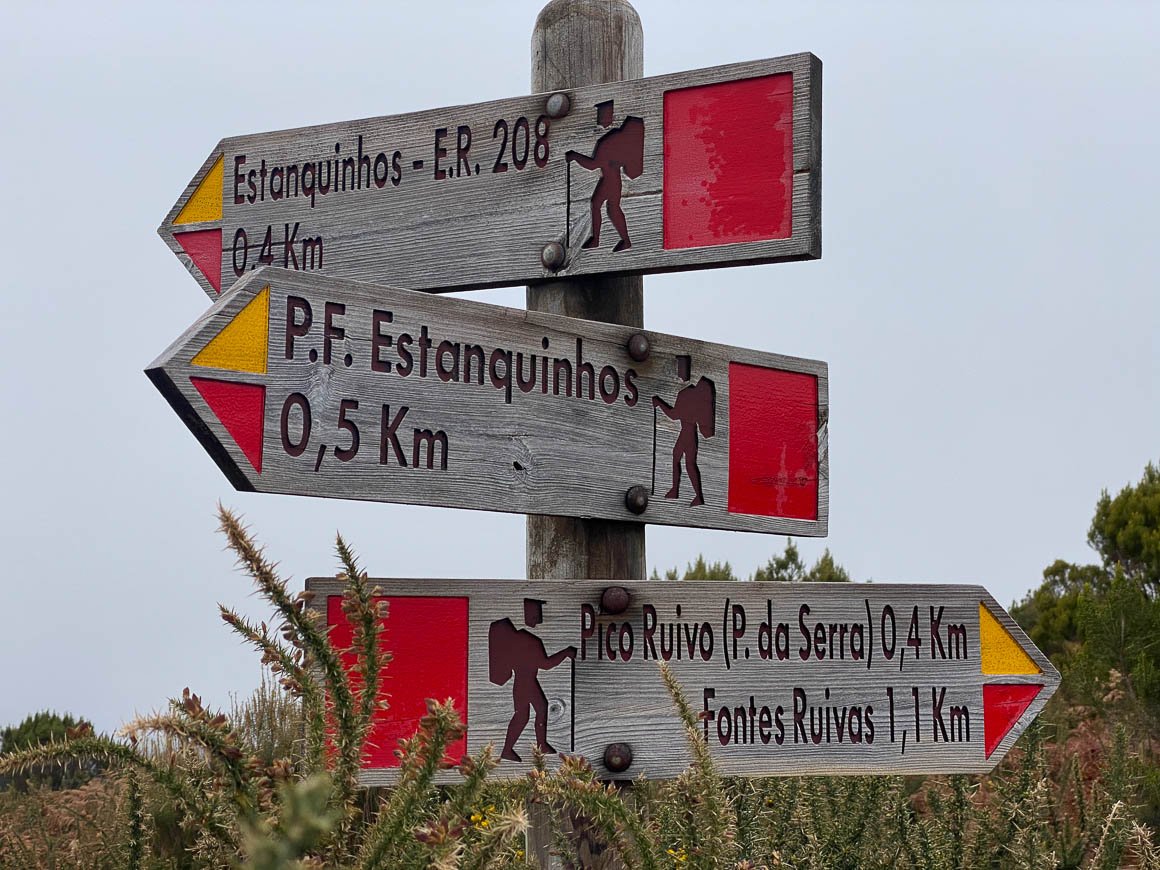
Photo: Chris Lininger
This pin will get you very close to where you need to park, but it is not actually accurate. From where that pin takes you, you need to carry on on the small road just off the main road (with the car).
Continue along for roughly 500 meters until you reach a stand of pines and a couple of old buildings. You can park here and this is where you start the hike. On Maps.me, you can route/see the parking spot at Estanquinhos.
Once you park, head towards the Pico Ruivo do Paul summit and take in the epic views. If you arrive before first light, this would be a great sunrise spot on a clear day.
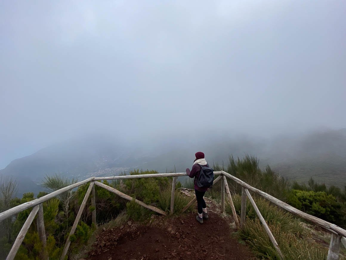
Photo: Chris Lininger
Head back down the way you came and look out for a small path on your left that immediately starts descending into the valley. I highly recommend using Maps.me for this hike – otherwise, some parts will be difficult to find, and there are almost no signs.
If you have no experience navigating or following maps, try to go with someone who is experienced.
- Distance: 8.5 Kilometers
- Duration: 3-4 hours with food breaks and photo ops.
- Difficulty: Moderate/Difficult
- Distance from Funchal to Trail Head: 1 hour+
Trail Conditions and Route
For the most part, this hike is not exceptionally difficult. This being said, the return section is steep and there are a few parts of exposure along the Levada walk. The total incline for the hike is around 700 meters.
The main issue we encountered is that there are very overgrown parts of the path, sometimes with thick thistle bushes, and one needs to bushwhack through. I would not recommend this hike after a lot of rain, as the paths will be very slippery and muddy (though the waterfalls will be awesome).
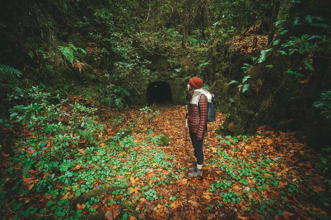
Photo: Chris Lininger
After descending into the valley, you come level with the old Levada do Plaino Velho on your left. This Levada walk has obviously not been in use for a long time, so you won’t find any water in it (just mud and plant debris).
From here, the path finds through the lush forest and through a series of old tunnels until you reach the magical waterfalls.
Once at the end of the waterfalls, look for a path on your right-hand side and continue down (do not try to go down the waterfalls!). The correct path on the right is a little hard to see. From the waterfalls, you should be climbing back up again within 20 minutes.
A steep ascent will eventually bring you back up towards the summit of Pico Ruivo do Paul and the parking area.
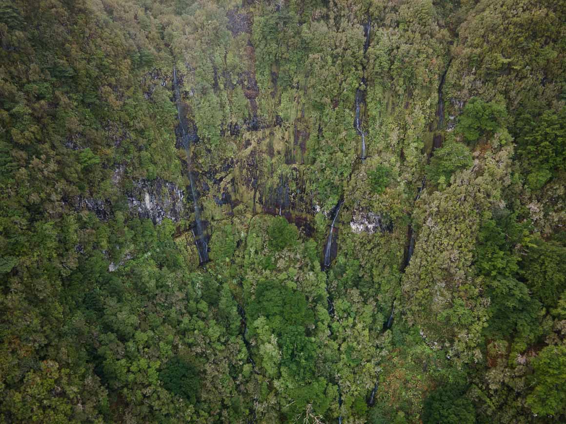
Photo: Chris Lininger
What to Pack for Hiking in Madeira
You should know by now that Madeira has many microclimates and different elevations. Sometimes one is blessed with sun and clear skies all day… While other times it feels like all four seasons can pass by in the span of a few hours.
The most important thing when going hiking in Madeira is to be prepared for the hike you are going on. Whether you’re hitting the Cabo Girao Skywalk, or Pico das Torres… Your personal safety and comfort depend 100% on what you decide to bring with you on any given hike.
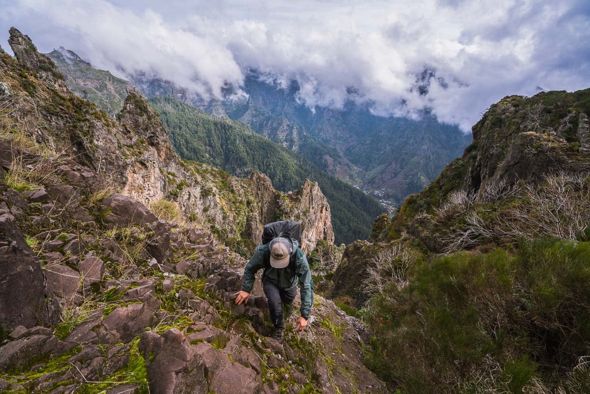
Photo: Jackson Groves
Below, I will cover what I pack for just about every hike I go on in Madeira Island.
I wrote a whole post on what to take hiking if you are interested in a deeper dive.
Choosing the Right Gear for Madeira
These are the big questions that I ask myself before embarking on any day hike:
- What is the weather forecast?
- Do I have enough food?
- What are the water sources like where I am going?
- Do I need to purify the water I will need to drink?
- What sort of layers will I need?
- How remote is the place I am going hiking?
- Do I have the minimum supplies for a worst-case scenario?
- Is there cell signal where I am going?
Weather forecasts, expected altitude, and general conditions for various Madeira regions can all be easily accessed online. Make sure you check these before you set out, which should help in the packing process.
Just because all looks well and sunny, does not mean you should leave your layers at home. This bears repeating: the weather can change in the blink of an eye here, especially in the mountains.
My Madeira Hiking Packing List
The must-have essentials:
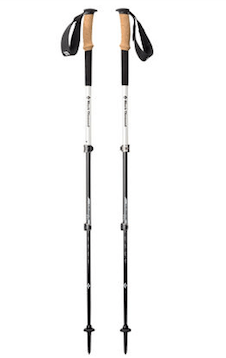
Black Diamond Alpine Carbon Cork
- Price > $$$
- Weight > 17 oz.
- Grip > Cork

Petzl Actik Core Headlamp
- Price > $$
- Weight > 1.9 oz
- Lumens > 160

Merrell Moab 2 WP Low
- Price > $$
- Weight > 2 lbs 1 oz
- Waterproof > Yes
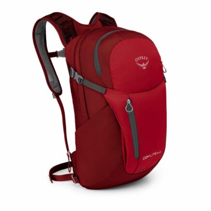
Osprey Daylite Plus
- Price > $$$
- Weight > 20 oz
- Capacity > 20L

GRAYL Geopress
- Price > $$$
- Weight > 16 oz
- Size > 24 oz
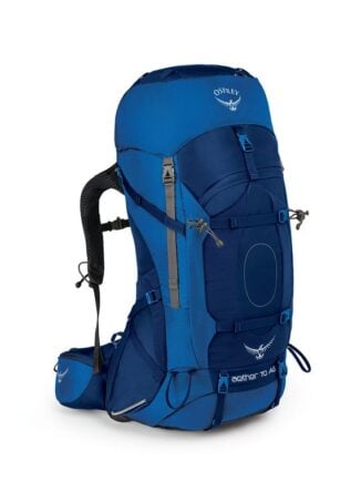
Osprey Aether AG70
- Price > $$$
- Weight > 5 lbs 3 oz
- Capacity > 70L
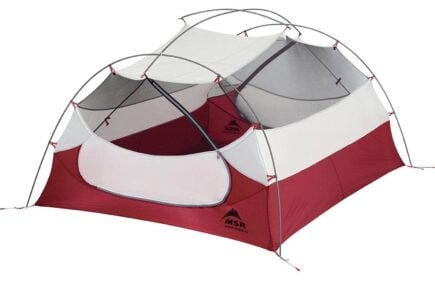
MSR Hubba Hubba NX 2P
- Price > $$$$
- Weight > 3.7 lbs
- Capacity > 2 person
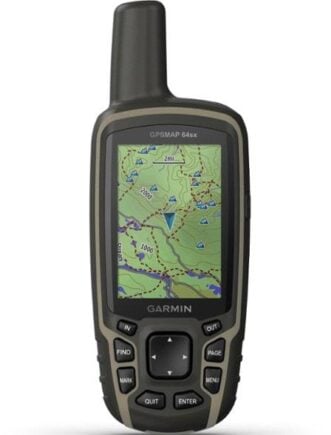
Garmin GPSMAP 64sx Handheld GPS
- Price > $$
- Weight > 8.1 oz
- Battery Life > 16 hours
Where to Stay while Hiking in Madeira
It’s important to perch yourself up in the right place when hiking in Madeira. The best place to base yourself is Funchal. Most hikes with within an hour of the capital, and there are plenty of transport options from here to the various trails. There are my top picks for where to stay:
Turim Santa Maria Hotel | Best Hotel in Madeira
With calming rooms, this hotel is one of the best places in Madeira to stay if you want to be in the heart of Funchal City. It’s a clean, modern building with a restaurant and bar on-site, which provides a delicious breakfast daily. It’s the best place in Madeira to stay if you’re after a bit of luxury after a day on your feet.
Jaca Hostel Funchal | Best Hostel in Madeira

Located in the heart of the Madeira area, this small hostel in Madeira has all the charm and colour you could want for your holiday. Located in Funchal, Jaca Hostel offers an inner yard, kitchen and balcony. Once a family home from the 19th century, it has since been remodelled to be a warm home for travellers.
It’s the perfect place to stay if you’re solo travelling to Madeira or if you’re just up for the social vibes of a hostel.
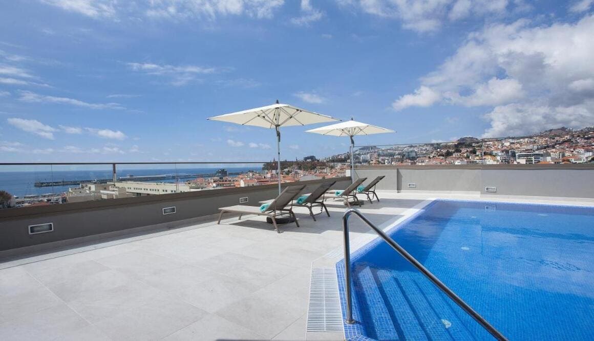
Pirate House Seafront Private Pool Garden Funchal | Best Airbnb in Madeira
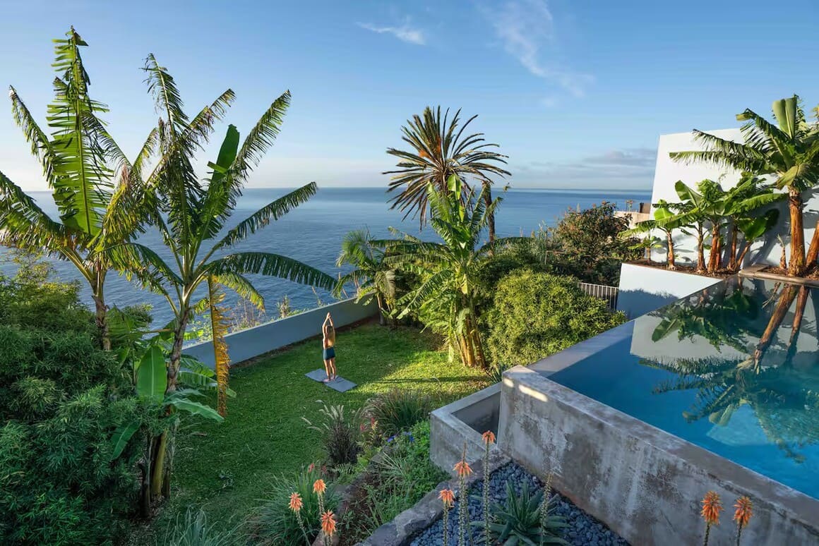
If you’ve got cash to splash for your trip to Madeira – splash it here! This incredible oceanfront house comes with an EPIC outdoor swimming pool and a big tropical garden overlooking the sea. With one double room and one room with two singles – it’s an ideal spot for families or group getaways.
If you can bring yourself to leave the property (harder said than done), you’ll be located in the charming Old Town centre. A mere 200m walk to the city centre, the beach and delicious restaurants.
Don’t Forget Your Madeira Travel Insurance
Make sure you get some good travel insurance, aka one that covers the activities you’re going to be doing; a whole lotta hiking!
ALWAYS sort out your backpacker insurance before your trip. There’s plenty to choose from in that department, but a good place to start is Safety Wing.
They offer month-to-month payments, no lock-in contracts, and require absolutely no itineraries: that’s the exact kind of insurance long-term travellers and digital nomads need.

SafetyWing is cheap, easy, and admin-free: just sign up lickety-split so you can get back to it!
Click the button below to learn more about SafetyWing’s setup or read our insider review for the full tasty scoop.
Final Thoughts on the Best Hikes in Madeira
There you have it, friends, I hope you have found this guide to the best hikes in Madeira informative.
Madeira Island is truly a special place to visit, and I feel very fortunate indeed to have the opportunity to live here for the time being. If you are looking for a world-class trekking destination for every experience level, it is all happening in Madeira.
Remember, I will be updating this post over the next months with even more epic hikes I end up on.
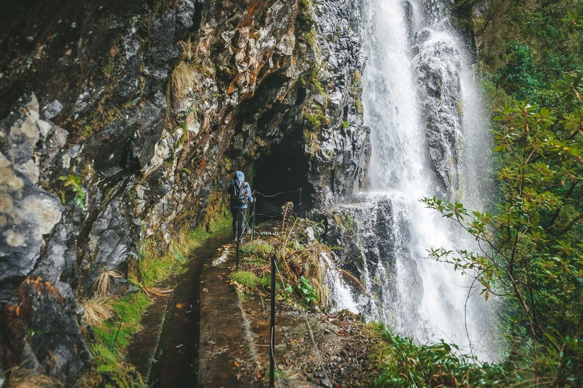
Photo: Chris Lininger
Buy Us a Coffee!
A couple of you lovely readers suggested we set up a tip jar for direct support as an alternative to booking through our links, since we’ve decided to keep the site ad-free. So here it is!
You can now buy The Broke Backpacker a coffee. If you like and use our content to plan your trips, it’s a much appreciated way to show appreciation 🙂